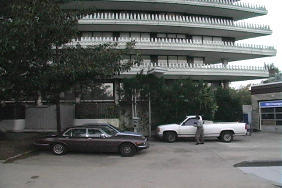
A cool mapping site (even though Salemtown not included yet)

Other than obvious physiological and emotional differences, I think I know two key differences between men and women: 1) admiration of the 3 Stooges 2) Fascination with maps. Yes, I know these are huge generalizations, but over the years I've found them to be pretty accurate.
When Google came out with their satellite 'Earth' software, I jumped on it like a right-winger on an anti-Cindy Sheehan tirade. The idea of being able to see my sister's rooftop in St. Louis (along with the arch) proved to be irresistable. You can be viewing Forest Park Zoo and then you can enter another address and the satellite shot zooms across town, country or continent from about 200 miles up and then it very coolly zooms down to your next destination. Not every city has been mapped to rooftop level (you can't see Nashville in detail yet), but there is a lot to peruse..
Just when I was settling into 'Earth', along comes the really really cool A9 site where you get STREET LEVEL pics of 20 cities (including for some weird reason, Fargo, ND where oddly enough, there seems to be perpetual snow). You can start at one end of 5th Avenue in NYC and literally see every building the entire length of the street (including Central Park).
They don't have Brooklyn yet, so I can't see our old house in Flatbush, but it's just a matter of time. Mostly I'm looking forward to A9 covering Nashville so that I can see what Norman's Market looks like from the sky.
By the way, the A9 generated picture above is the Watergate Apartment House, a particular favorite of mine...